

In A Nutshell
Catholic priest and exile Olaus Magnus is perhaps best known for his chronicle of medieval life in Scandinavia, presented in his epic work Historia de gentibus septentrionalibus (“A History of the Nordic People”). He also spent 12 years of his life creating an elaborately detailed map of Scandinavia. Not only has it been found to be eerily accurate, but it’s also been found that swirls and squiggles previously thought be decoration actually coincide with real oceanic phenomenon. Also on the map are amazingly detailed drawings of sea monsters, accompanied by thorough descriptions of the mythical beasts then thought to roam the sea.
The Whole Bushel


Swedish exile Olaus Magnus’s intricately detailed, beautifully drawn map of medieval Scandinavia was originally printed in such a small quantity that it was lost and forgotten about for nearly 300 years. It took the Catholic priest 12 years to create, and it was finally published in 1539 under the title “Carta Marina.” Only two original copies have ever been found—one in Munich, the first copy that rediscovered the map, and another that was purchased by the Uppsala University Library.
As a useful tool and when it’s judged on the basis of its cartography, it’s surprisingly accurate, especially considering it was done by an amateur cartographer with no modern tools. So accurate, in fact, that an examination of the original maps show something surprising.
The original map has a number of swirls drawn on the waters around Scandinavia. Reprints were done on copperplate in 1572, but because of the medium and the much smaller scale, most of the detail was lost—including the swirls. It was only with the rediscovery of the much larger, much more detailed original map that the “decorations” were finally understood. A comparison to modern thermal images shows that many of the swirls and symbols on the map correspond with ocean phenomenon.
Where the Gulf Stream meets the colder northern waters, the different temperatures create massive, slow spiraling currents. These are marked on this 1539 map.
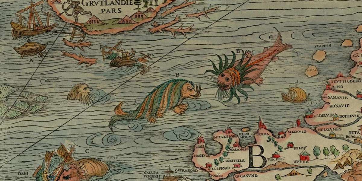
Many of the details that are on the map came from stories Magnus heard from sailors and fishermen who would be able to point out just where these phenomenon were, even if they didn’t know why they happened. They also told stories of sea monsters—and those, too, Magnus included in his map, along with complete descriptions of the monsters in an accompanying text.
It’s these drawings that are truly breathtaking. Some are interpretations of creatures we now know to be real, like the manta ray, the octopus, the swordfish, and the walrus.
Others give some incredible insight into the fantastic world that those of the medieval age must have thought was just outside their borders. The map warns of islands that aren’t really islands at all, but the hunting grounds of massive creatures trying to fool sailors into landing their ships on their backs, only to be pulled beneath the water.
Perhaps one of the most fascinating is the Duck Tree. As far as people were concerned, ducks appeared in the spring, left for a while, and more ducks came back. So Magnus included a Duck Tree, that bore ducklings as fruit. Ducks were never seen mating or laying eggs, so it was as good an explanation as any.
Not just a sea map, the land masses are filled with amazing drawings as well, each capturing a picture of 16th-century Scandinavian life. Two reindeer pull a sleigh while a maid milks another. Bundles of fish surround what much have been bountiful lakes. Kings sit atop their decorative thrones while travelers lead snowshoed horses over mountains.
Magnus had left his native Sweden and moved to Italy in order to preserve his right to practice his Catholic faith. For most people in Rome, the north was a mysterious, marvelous land, and Magnus’s map undoubtedly made it more so.
Interestingly, the map is also one of the earliest examples of something else. Neither of the original surviving copies were in color, and according to Magnus, that was because the buyer was supposed to color it in the way he or she desired.
Show Me The Proof
Featured image credit: James Ford Bell Library, University of Minnesota (includes photo of full map)
Slate.com: Here Be Duck Trees and Sea Swine (includes interactive map/monster guide)
The Cipher Project: Exploring Carta Marina
Carta Marina at Uppsala University Library


